CONSUMERS.SECONDSTREETAPP.COM
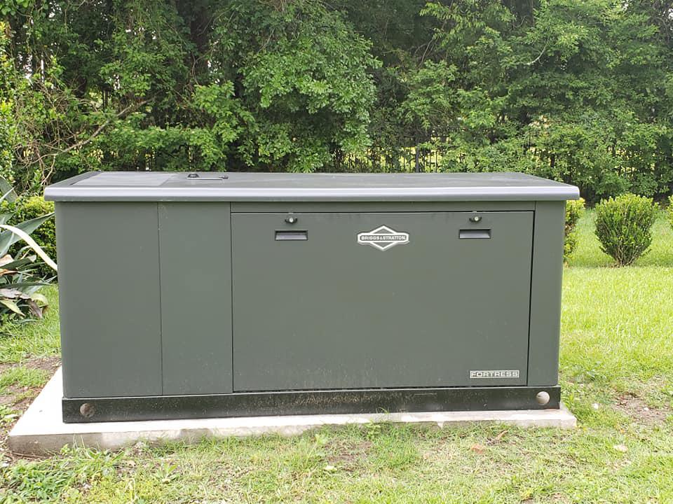
Check out K-Gen Electrical & Generator Services.
Terrebonne Parish Office of Homeland Security and Emergency Preparedness
14 September at 01:39 ·
Latest from the National Hurricane Center for Tropical Storm Sally
Tropical Storm Sally Intermediate Advisory Number 9A
NWS National Hurricane Center Miami FL AL192020
700 PM CDT Sun Sep 13 2020
...SALLY FORECAST TO STRENGTHEN AND SLOW DOWN...
...LIFE-THREATENING STORM SURGE, HURRICANE-FORCE WINDS, AND HEAVY
RAINFALL EXPECTED ALONG PORTIONS OF THE NORTHERN GULF COAST
STARTING ON MONDAY...
SUMMARY OF 700 PM CDT...0000 UTC...INFORMATION
----------------------------------------------
LOCATION...27.9N 86.2W
ABOUT 160 MI...260 KM S OF PANAMA CITY FLORIDA
ABOUT 195 MI...315 KM ESE OF THE MOUTH OF THE MISSISSIPPI RIVER
MAXIMUM SUSTAINED WINDS...60 MPH...95 KM/H
PRESENT MOVEMENT...WNW OR 295 DEGREES AT 9 MPH...15 KM/H
MINIMUM CENTRAL PRESSURE...996 MB...29.41 INCHES
WATCHES AND WARNINGS
--------------------
CHANGES WITH THIS ADVISORY:
None
SUMMARY OF WATCHES AND WARNINGS IN EFFECT:
A Storm Surge Warning is in effect for...
* Port Fourchon Louisiana to the Mississippi/Alabama Border
* Lake Pontchartrain, Lake Maurepas, and Lake Borgne
A Hurricane Warning is in effect for...
* Morgan City Louisiana to Ocean Springs Mississippi
* Lake Pontchartrain and Lake Maurepas including metropolitan New
Orleans
A Storm Surge Watch is in effect for...
* Mississippi/Alabama Border to the Alabama/Florida Border
A Hurricane Watch is in effect for...
* East of Ocean Springs to the Alabama/Florida Border
A Tropical Storm Warning is in effect for...
* East of Ocean Springs to Indian Pass
* Intracoastal City Louisiana to west of Morgan City
A Tropical Storm Watch is in effect for...
* Indian Pass to Ochlockonee River Florida
At 700 PM CDT (0000 UTC), the center of Tropical Storm Sally was located near latitude 27.9 North, longitude 86.2 West. Sally is moving toward the west-northwest near 9 mph (15 km/h), and this motion is expected to continue through tonight. A slower west-northwestward motion is expected Monday and Monday night, followed by a further decrease in forward speed and a turn to the northwest Monday night and Tuesday. On the forecast track, the center of Sally will move over the north-central Gulf of Mexico tonight and Monday, and approach the north-central Gulf Coast within the hurricane warning area Monday night. Sally is expected to move slowly northward near the southeastern Louisiana or Mississippi coasts through Tuesday.
Maximum sustained winds are near 60 mph (95 km/h) with higher gusts. Strengthening is expected over the next day or so, and Sally is forecast to become a hurricane on Monday, with some additional strengthening possible before the center crosses the northern Gulf Coast.
Tropical-storm-force winds extend outward up to 125 miles (205 km) primarily to the east of the center.
The estimated minimum central pressure is 996 mb (29.41 inches).
STORM SURGE: The combination of a dangerous storm surge and the
tide will cause normally dry areas near the coast to be flooded by
rising waters moving inland from the shoreline. The water could
reach the following heights above ground somewhere in the indicated
areas if the peak surge occurs at the time of high tide...
Mouth of the Mississippi River to Ocean Springs, MS including Lake Borgne...7-11 ft
Port Fourchon, LA to Mouth of the Mississippi River...4-7 ft
Ocean Springs, MS to MS/AL Border...4-7 ft
Lake Pontchartrain and Lake Maurepas...4-6 ft
MS/AL Border to AL/FL Border including Mobile Bay...2-4 ft
AL/FL Border to Chassahowitzka, FL including Pensacola Bay,
Choctawhatchee Bay, and Saint Andrew Bay...1-3 ft
Burns Point, LA to Port Fourchon, LA...1-3 ft
NOAA NWS National Hurricane Center
13 September at 11:56 ·
The National Hurricane Center is issuing advisories on Hurricane Paulette, located over the western Atlantic (www.nhc.noaa.gov/#Paulette), Tropical Depression Rene, located over the central Atlantic (www.nhc.noaa.gov/#Rene), on Tropical Storm Sally, centered over the eastern Gulf of Mexico (www.nhc.noaa.gov/#Sally), and on Tropical Depression Twenty, located over the eastern tropical Atlantic (www.nhc.noaa.gov/#Twenty).
Elsewhere on this Sunday morning, a surface trough over the west-central Gulf of Mexico is producing limited shower activity. Any development of this system is expected to be slow to occur while it moves southwestward and then southward at 5 to 10 mph over the western Gulf of Mexico during the next few days. It has a low (20 percent) chance of formation during the next five days.
There's an area of low pressure ocated a little more than a hundred miles west of the Cabo Verde Islands. Although the low's circulation appears somewhat elongated, the associated shower and thunderstorm activity is showing some signs of organization. Environmental conditions are expected to be conducive for additional development during the next day or so while the system moves toward the north-northwest at 5 to 10 mph, and a tropical depression is likely to form before it moves over colder waters and into an area of strong upper-level winds by Tuesday. It has a high (70 percent) chance of formation during the next five days
And, a tropical wave is forecast to move off the west coast of Africa within the next couple of days. Some gradual development of the system will be possible thereafter as the disturbance moves slowly westward over the far eastern tropical Atlantic. It has a low (20 percent) chance of formation during the next five days. www.hurricanes.gov
NOAA NWS National Hurricane Center
12 September at 12:01 ·
...DEPRESSION NEAR EXTREME SOUTHWEST FLORIDA PENINSULA...
...EXPECTED TO BECOME A TROPICAL STORM OVER THE GULF OF MEXICO LATER TODAY OR TONIGHT...
A Tropical Storm Watch continues in effect for the Florida Panhandle from the Ochlockonee River to the Okaloosa/Walton County Line. Tropical storm conditions are possible in the watch area by Sunday night.
Wind gusts to tropical-storm force are possible over South Florida today, and a tornado or two is possible today and tonight.
Interests elsewhere along the northern Gulf Coast should monitor the progress of this system. Tropical storm or hurricane watches could be issued for a portion of that area on Saturday. For storm information specific to your area, including possible inland watches and warnings, please monitor products issued by your local National Weather Service forecast office - www.weather.gov
At 8 a.m. EDT, the center of Tropical Depression Nineteen was located inland over South Florida about 55 miles (90 km) southeast of Naples. The depression is moving toward the west near 9 mph (15 km/h), and a turn toward the west-northwest is expected later today. A west-northwestward or northwestward motion with a decrease in forward speed is then expected during the next couple of days. On the forecast track, the center is forecast to move over the southeastern and eastern Gulf of Mexico later today and Sunday, and then move over the north-central Gulf of Mexico Sunday night and Monday.
Maximum sustained winds are near 35 mph (55 km/h) with higher gusts. Strengthening is expected when the center moves over the Gulf of Mexico, and the depression is expected to become a tropical storm later today or tonight and gradually intensify Sunday and Monday. The next name on the list is Sally.
Tropical Depression Nineteen is expected to produce total rainfall accumulations of 2 to 4 inches, with isolated maximum amounts of 6 inches, across west-central and southern Florida, including the Florida Keys through Sunday. This rainfall may produce scattered flash flooding and prolong high flows and ongoing minor flooding on rivers across Central Florida. The depression is then expected to produce total rainfall accumulations of 2 to 4 inches, with isolated maximum amounts of 6 inches, across portions of the central Gulf Coast Sunday through Tuesday morning. This rainfall could also produce scattered flash flooding.
The next complete advisory will be issued by NHC at 11 a.m. EDT - www.hurricanes.gov
FOX8LIVE.COM
Storm impacts possible next week
TMJ4.COM
Waukesha Generac teams to deploy to Louisiana in response to Hurricane Delta
South Louisiana Electric Cooperative Association - SLECA
October 6 at 9:00 AM ·
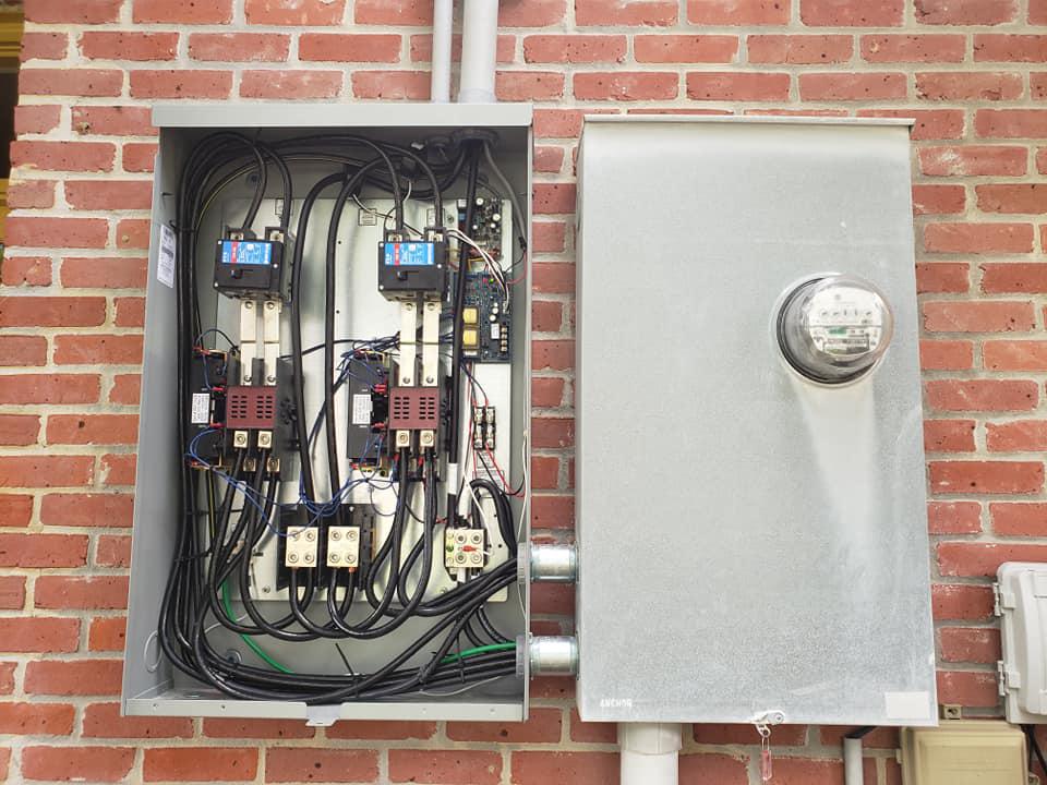
Under no circumstances should a meter be removed or pulled. It is illegal to tamper with a meter because it creates other safety hazards. Generators should be hooked up properly according to the manufacturers recommendations by a licensed electrician with a switch that isolates the utility from the consumers generator.
WVUE FOX 8 News
October 5 at 6:53 AM ·
7 AM UPDATE: Tropical Storm Delta has formed. Projected to be a Cat 2 at landfall along the northern Gulf coast later this week.
US National Weather Service New Orleans Louisiana
October 4 at 10:29 PM ·
Here is the 10 pm advisory on what is now Tropical Depression 26 (TD26) in the Caribbean Sea south of Jamaica.
TD26 is expected to become a tropical storm early Monday and move to the northwest across the northwest Caribbean Sea. This system is expected to continue to strengthen into a hurricane as it moves over or near western Cuba on Tuesday, and continue to move northwest then northward across the central and northern Gulf of Mexico during the middle to latter part of the week.
This system could result in direct impacts to the northern Gulf coast region late this week. Please, do not focus on the exact forecast points. Everyone along the northern Gulf coast should be monitoring this system, and future forecast updates.
South Louisiana Electric Cooperative Association - SLECA
October 29 at 6:31 AM ·
Under no circumstances should a meter be removed or pulled. It is illegal to tamper with a meter because it creates other safety hazards. Generators should be hooked up properly according to the manufacturers recommendations by a licensed electrician with a switch that isolates the utility from the consumers generator.
HOUMATODAY.COM
Curfew ordered for all of Terrebonne Parish
South Louisiana Electric Cooperative Association - SLECA
October 28 at 5:59 PM ·
A message from SLECA
It appears that the worst has passed our area. Hurricane Zeta moved fast but caused a lot of damage while it crossed our service territory. Now, that the winds have died down, all of our crews are now being dispatched and will be working all night to restore power. There are a lot of outages caused by the high winds. Some will be easier and less time consuming to restore then others. We ask that you please be patient. Our goal is to restore power as quickly and safety as possible.
South Louisiana Electric Cooperative Association - SLECA
October 28 at 3:00 PM ·
We have an outage on feeder 12 which includes from the 470 block of Bayou Dularge going North to Chet Morrison. As soon as winds subside we will be sending crews out.
We have an outage on feeder 12 which includes from the 470 block of Bayou Dularge going North to Chet Morrison. As soon as winds subside we will be sending crews out.
Stop by to meet Eragon.
PWRview Home Energy Monitoring system allows owners to monitor and manage home energy usage!
Happy New Year from all of us at K-Gen Electrical & Generator Services!
Did you know Generac offers 24/7 - 365 day Customer Support? Generac's team is standing by all day, every day from Wisconsin to answer any questions you might have. 888-GENERAC
Merry Christmas from all of us at K-Gen!
Winter Storm Shirley will spread freezing rain, sleet, and snow from Texas to the mid-Atlantic. This storm has the potential to create hazardous travel conditions and knock out power in some areas. Stay safe & informed! https://weather.com/storms/winter/news/2021-02-09-ice-storm-ozarks-ohio-valley-mid-atlantic-snow
WEATHER.COM
Winter Storm Spreading Ice, Snow From Mid-South to Mid-Atlantic | The Weather Channel - Articles from The Weather Channel | weather.com
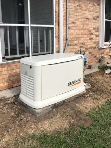
Collins has had a Generac in his life since 2013. If you are looking for reliability in a generator, look no further. Our team is here to help at K-Gen Electrical & Generator Services 985-688-8172.
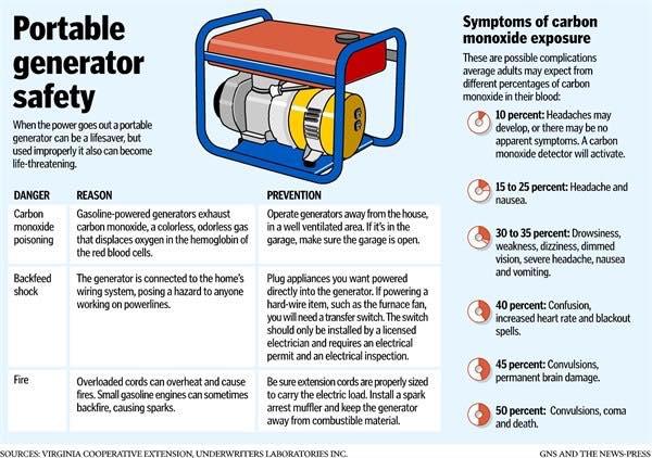
Is your portable generator ready to withstand and handle the winter weather?
There's a reason 8 out of 10 home standby generators are Generac.
5-Year Warranty.
Engineered & Built in the USA*.
24/7-365 Customer Care.
Mobile Link Connectivity FREE with every Guardian generator.
That's the Generac Promise. That's why we carry the Generac brand. To learn more visit www.kgenelectrical.com or give us a call at 985-688-8172
Did you know Generac offers 24/7 - 365 days Customer Support? Generac's team is standing by all day, every day from Wisconsin to answer any questions you might have. 888-GENERAC
In today's world, losing power means a lot more…missing work, virtual school. Backup power is a critical element of being prepared. Learn how K-Gen Electrical & Generator Services can help you prepare. 985-688-8172